
INTRODUCTION
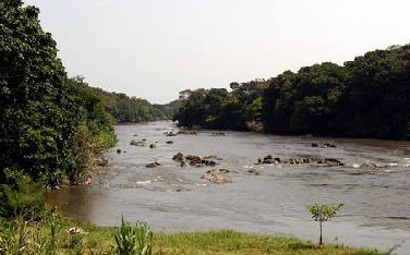
Semuliki River is a major river in the Democratic Republic of Congo (DRC) and Uganda in Central and East Africa. It is 140 kilometres long.
It flows north from Lake Edward in Beni Territory, Nord-Kivu, D.R.C avoiding the Rwenzori Mountains on its Right (East), emptying into Lake Albert in the Albertine Rift, Irumu Territory, Ituri Province, D.R.C overlooking the Blue Mountains to its left in the west.
Its mouth is near the Village of Katolingo in Kanara sub-county, Ntoroko district, Uganda; along its lower reaches, it meanders extensively, forming part of the international border between the DRC and the western Ugandan districts of Bundibugyo and Ntoroko, near the Semliki National Park.
Increasing snow melt from the Rwenzori, overgrazing, and other alterations to the watershed have caused bank erosion and frequent changes to the course of the meandering river’s lower reaches.
In some places, Uganda is losing up to 10 metres (33 ft) of land per year on its side of the river to erosion and silt from the Semliki is gradually filling in the southern end of Lake Albert.
In other places, the DRC is losing territory as the changing river course alters the apparent location of the border.
How Increased Human activities have threatened government efforts to protect and restore River Semliki in Ntoroko District
In 2018, the Ministry of Water and Environment contracted Natural Resource Defense Initiative (NRDI) to restore and protect River Semliki; the project ended last year.
However, efforts by the government have been interfered with by increasing human activities such as animal grazing, bush burning in buffer zones and destruction of fencing on river banks.
The district leaders have raised a red flag appealing to the government to look for more funds to conserve the river.
The river banks have continued to collapse, and the river has moved over 200 meters inside the Ugandan side from its original boundaries of Uganda and DRC.
Rules need to be enforced to ensure that all human activities carried out along the river banks are stopped; all those with animal farms that border the river should not be allowed to graze their animals near the river banks as it has greatly affected restoration plans.
“Governments’ worry is that the river banks have continued to collapse on the Uganda side over the past years; the country has faced many floods resulting in people losing their properties and lives from this river.
In some areas where the Government has erected fences, the cattle keepers have destroyed them to allow their animals to access rivers for grazing and getting water.
Measures to put in place to restore River Semliki
- Identifying hotspot areas where collapsing occurs, fence off and plant trees.
- Build water troughs away from river banks for cattle keepers where they drink water from.
- Elect river bank management committees to oversee the sustainability of the intervention.
- The leadership of the Ntoroko district should engage the Ministry of Water to increase the funding.
- The government should develop a long-lasting solution of establishing gabions, facing off the river bank and stopping all activities.
- Environmentalists, nongovernmental organizations, civil society organizations, and stakeholders call upon the government’s intervention to protect the river as the problem of collapsing of the river banks is beyond their control and also needs government to inject many resources to save the river.
CONCLUSION
The biggest challenge that has blocked the restoration is that many hotspots need to be restored, but there are limited resources; hence more donors are needed to support this intervention. The hotspot areas that have been worked on include Kyapa, Haibale, Kayaja, Rukora, Kyagabukama, Kabimbiri, Kadigidi and Kiraga.
